Coleridge's 'Circumcursion': Mappings
Coleridge's 'Circumcursion': Base Map
/Coleridge Base Map BB Small.gif) |
This is the base map: it charts Coleridge's movement across the Cumbrian topography; it shows where he stayed on each night of his short tour; and it establishes a distinction between those places which Coleridge claims that he actually visited and those sites which he merely mentions, or looks towards, from positions of distance and detachment.
This kind of static base GIS is cartographically limited and conceptually limiting. Nevertheless, the map offers a necessary foundation for further mappings and it immediately highlights a series of spatial patterns within Coleridge's textual account of place. This simple mapping of Coleridge's route illustrates both the spatial concentration and the circularity of his walk through the Cumbrian landscape. In other words, this base map offers a visual shorthand for the spatial patterns suggested by Coleridge's description of his Lake District tour as a 'circumcursion': it highlights the bounded, enclosed and cyclical nature of his pedestrian journey.
Alongside this, it is apparent that Coleridge's geographical focus lies, predominantly, in the western half of the county of Cumbria. It is also significant that, at the most easterly point of his route (the walk north-westwards from Grasmere to Keswick), Coleridge's textual account contains relatively few geo-specific references. As this terrain was familiar to Coleridge, he is less interested in documenting his movement through this particular space.
By handling Coleridge's place names as quantitative data, it seems that his greatest interest and focus lies in the west: he even manages to make it as far as the Irish Sea, spending a night in the coastal village of St Bees. Similarly, it is noticeable that Coleridge's textual account of his spatial experience largely eschews the main villages and towns within the Lake District whereas these settlements provided more of a focus for Gray's interaction with the region. Coleridge's journey might begin and end at Greta Hall, Keswick; but, for the most part, his ramble takes him through Cumbria's rural topography.
Finally, Coleridge's base map shows a proliferation of place name references, many are which are packed tightly together in pockets or clusters. A large proportion of these names refer to places Coleridge mentions but, apparently, does not visit. Yet, there are also a significant number of places marked by red spots, illustrating the fact that Coleridge's text records his immediate experience of that particular location.
Once again, though, the creation of the base GIS has led to a cartographical anomaly. Towards the bottom of the map, a place name is marked by a red spot, thereby indicating that Coleridge claims to have visited this specific site; but, curiously, this place/spot sits south, and beyond, the line of the writer's route across the Cumbrian terrain. This anomaly offers another reminder that the literary cartographer needs to remain wary of possible mis-mappings generated by the use of spatially-referenced databases.
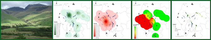
Coleridge's 'Circumcursion': Smooth Surface Map
/New STC - y surface small.GIF)
/New STC - all surface small.GIF)
As with the static mappings of Gray's 'Journal', the use of a density smoothing technique offers an arresting cartography of Coleridge's representation of space. The first GIS maps out only those geo-specific sites which Coleridge reports that he has actually visited during his 1802 tour of the Lakes; whilst the second GIS documents all of his place name references, including those locations which he does not pass through.
For the most part, these GIS maps offer a relatively uniform shading across the landscape of the Lakes: a uniformity which suggests that Coleridge displays a consistency in the intensity and depth of his accounts of particular places.
Strikingly, the eye is directed towards a scarlet 'hot spot': an intense, centripetal space to be found towards the middle of the regional maps. The centre of this 'hot spot' is to the east of the head of Wast Water, at a location where Sca Fell runs down in to the vale of Eskdale. These smooth surface GIS maps visually confirm that Coleridge's account of his encounter with the highest fells in England - and, more particularly, his famous descent of Broad Stand - lies at the imaginative core of his textual mapping of the area.